March 29 Storm Update
- WeatherSD
- Mar 29, 2022
- 2 min read
A typical early spring storm looks to impact us today and continues to bring chances of precipitation tonight and into Wednesday. A mixture of thunderstorms, rain, and heavy wet snow is expected with this storm.
Starting today, rain showers have already developed over northwest, South Dakota, and will expand in coverage as we move closer to the afternoon.

By the middle of the afternoon, rain showers are expected to change over to snow over the Black Hills. A Winter Weather Advisory is in effect for the northern Black Hills from 3:00 pm MDT until noon MDT on Wednesday.

By the start of the late afternoon and early evening hours, rain showers and thunderstorms will develop over the east. Some of the rain showers in the west are expected to change over to snow.


During the overnight hours, the rain/snow line will shift eastward impacting the northeast first. Rain showers and possibly a few thunderstorms will continue over the southeast.

By the morning hours on Wednesday and during the morning commute, the precipitation would have changed over to all snow. Snow is expected to back develop across the eastern and southern regions of the state, continuing the chances of snow throughout the day.


On Wednesday afternoon, light snow chances will continue but start to come to an end by the evening hours.


As thunderstorms are in the forecast, none of these are expected to be severe. This story is different in Iowa as the northeast region of the state may see an isolated strong to severe storm today.

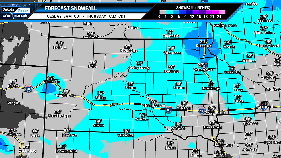
Snowfall amounts generally look to be light with amounts under two inches expected. The northeast, South Dakota, and into the northern Black Hills will see higher amounts of three to six inches in the forecast. The lightest amounts will be across the far west and amounts looking to remain under one inch.

Helpful Links:

